

| LC Station | LLA Station | Site ID | DEQ Station ID | Latitude | Longitude |
|---|---|---|---|---|---|
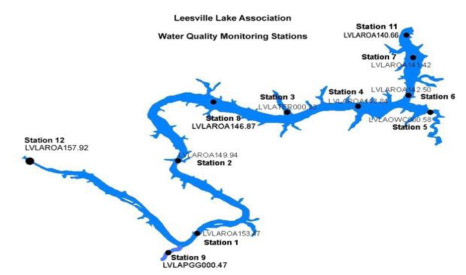
| Leesville Lake Dam | 11 | 2636 | LVLAROA140.66 | 37.0916 | -79.4039 |
| Leesville Lake Marina | 5 | 1275 | LLAOQC000.58 | 37.05939 | -79.39574 |
| Tri County Marina | 3 | 1273 | LLATER000.33 | 37.05942 | -79.44489 |
| Mile Marker 6 | 8 | 1373 | LLAROA146.87 | 37.06320 | -79.47110 |
| Mile Marker 9 | 2 | 1272 | LLAROA149.94 | 37.03993 | -79.48233 |
| Toler Bridge | 1 | 1271 | LLLAROA153.47 | 37.01090 | -79.47530 |
| Pigg River | 9 | 1374 | LLAPGG000.47 | 37.00430 | -79.48590 |
| SML Tail Waters | 12 | 2637 | LVLAROA157.92 | 37.0382 | -79.531306 |
The link below is to a web app that when saved to your device will collect and save data when out of range of a wifi.
When you get back in wifi range at the end of the day simply upload to the server.