Leesville Lake Association
Mile Markers
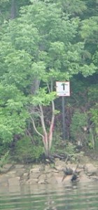
The last of new mile markers was installed the Thursday before Memorial Day 2006. The sixteen 2 x 2 ft. 18 gauge aluminum sheets have the orange numbers one through sixteen and an orange border contrasting with a white night reflective background. The metal posts upon which they were mounted were driven into the ground. They were manufactured and installed by member Bill Estes of Estes Sign Company with the help of committee chairman Bill Wallace and committee members Mike Lobue and Pete Pettit.
A survey done previously revealed that half of the original markers, installed in the 1960’s, were either missing or damaged and the accuracy in the placements was questionable. The Association felt the need for a complete system of accurate markers for navigation on the lake as well as location information for rescue crews in the event of an accident.
The signs were placed near the 613 ft. elevation on the north shore so the face of each sign would be toward the sun or moon for best illumination.
The project was funded by association dues. The Committee recognized the need for volunteers to remove foliage from around the markers for visibility reasons.
This type of maintenance will be needed in the future. You can participate in our Adopt a Mile Marker program. Just contact a board member.
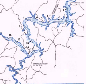
Find GPS information on marker placement below the map.
| 1 | 37-04-52.3N | 79-24-15.7W |
| 2 | 37-04-00.9N | 79-24-14.4W |
| 3 | 37-03-47.2N | 79-25-9.1W |
| 4 | 37-03-39.9N | 79-26-13.2W |
| 5 | 37-03-31.9N | 79-27-13.1W |
| 6 | 37-03-53.7N | 79-28-11.6W |
| 7 | 37-03-53.0N | 79-29-13.1W |
| 8 | 37-03-08.0N | 79-29-21.6W |
| 9 | 37-02-27.2N | 79-28-58.4W |
| 10 | 37-01-46.6N | 79-28-34.1W |
| 11 | 37-01-17.6N | 79-27-40.1W |
| 12 | 37-00-55.4N | 79-28-10.2W |
| 13 | 37-00-24.7N | 79-28-56.4W |
| 14 | 37-01-07.4N | 79-29-32.5W |
| 15 | 37-01-41.3N | 79-30-17.7W |
| 16 | 37-02-05.6N | 79-31-13.1W |


